Your Garmin Edge 800 bike GPS can provide true turn by turn navigation. Here’s a great tutorial guide on how to plan and follow a route on your edge 800. Route planning has never been easier.
First things first – your maps
I’m going to use free OSM maps as a common denominator because anyone can use them, they’re free, and routable. If you’re in the UK, grab the talkytoaster maps here. If you need help, watch my tutorial video showing how to install the maps.
Of course, if you’re using commercial maps like the Garmin GB Discoverer (All of Great Britain,1:50K), or the garmin city navigator (see my comparison post here), then these will also work just fine, since they are fully routable.
Looking for the best price on a new Garmin Edge?
You can save loads of time checking all the different stores, because we’ve done it for you!
Just view the pages at “Which Garmin is right for you?.
My personal choice for road cycling is the City Navigator map, as it offers the best balance between clarity and detail.
Search for City Navigator maps on Amazon
If you need the full City Navigator map, here’s some live price data – check the region before you buy!
The best way to create a route/course to follow
There are tons of sites out there which will let you draw routes on a map and then allow you to download the route as a gpx or tcx file. There does seem to be some variation in the outputs they produce, and in turn these can be interpreted differently by the Garmin. My advice is to use www.ridewithgps.com – it’s free to use, and very simple. Just point and click on the map, and it will “snap” to the roads. Make a mistake? Just click the undo button.
When you’re done, you can export the file in various formats. I always use the GPX track option, but TCX works fine too. I’ll say that again. Export the file as a GPX track, or a TCX file!
Getting the GPX/TCX file onto your Garmin
This step is very simple – just connect the garmin to your computer via the USB cable, and open it up so you can see the files inside (on most computers you’ll get an autoplay pop up – just choose “open folder to view files”. If you have an SD card in your Garmin, you should get two autoplay options – one for the internal memory in the Garmin, and one for the SD card. It’s better to use the SD card.  Open the Garmin folder, then the NewFiles folder. Copy your GPX/TCX file into the NewFiles folder. You can then disconnect the USB lead.
Making sure the settings on the Edge 800 are correct
Before you head out, you need to make sure a few settings are dialled in properly. The Garmin has all sorts of options for things like recalculating routes if you go wrong, whether to avoid certain types of roads, and so on.
If these aren’t set up right, you’ll have problems, so listen carefully!
Set the controls…
The following settings only need to be done once. So set ’em and forget ’em.
To access the settings, press the Menu button, then:
1. Press the Spanner icon in the bottom right.
2. Choose System
3. From here, we’ll be changing the Map and the Routing settings
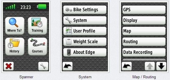
Edit each setting to resemble the images below.
(Note: Map Visibility can be left on Auto)
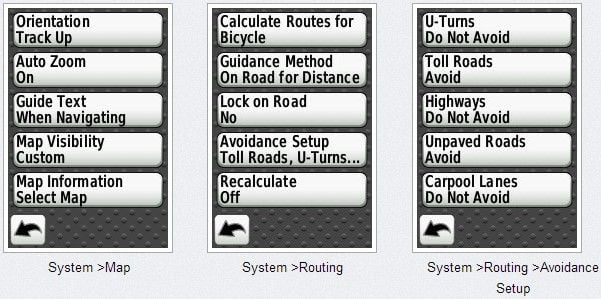
Here’s another way of viewing it, so you can see how the menus link together.
Click to enlarge.

Settings for your Edge 800 (Click to enlarge)
Bonus: Customise your Edge 800/810
 Take a look at these instructions and free downloadable wallpaper images to jazz up your GPS!
Setting your course up
Now that your Map and Routing settings are just exactly perfect, there’s only one more thing to do.
Load the Course list (Main Menu > Courses), choose your course to load it up, and hit the spanner icon.
Make sure Turn Guidance is ON.
#You need to repeat this step, each time you load a new course, for the first time.
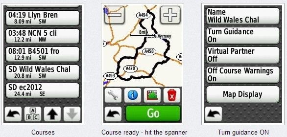
From this last screen, hit the back button and then finally the big green GO button.
The unit may ask you if you wish to navigate to the start of the course.
If you know where you’re going, say NO.
The unit will then take some time saying “Calculating…”, with a percentage indicator. Once done, your route will be highlighted in purple on the map, and you should get Turn by Turn directions popping up on screen in advance of the junctions,
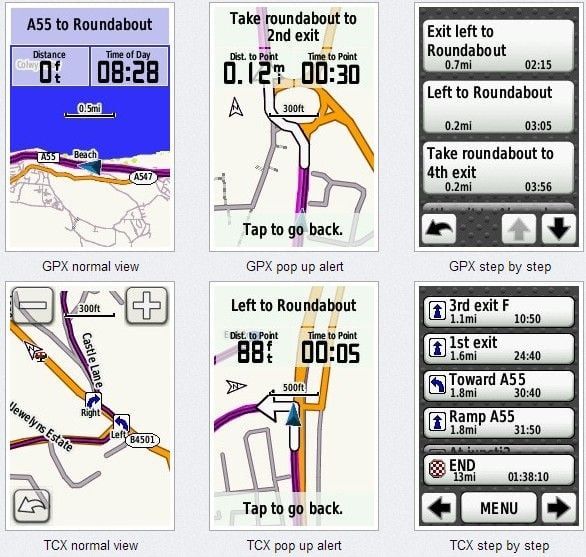
Note, if you use TCX files, you’ll also get little arrows on the map, as well as the pop up warnings.
Here’s some more screenshots showing the difference between navigating with a GPX track, and a TCX file.
I hope that’s helped a few people out. I know from reading various forums that a lot of people struggle with the official Garmin manual.
Happy course following! Please share this article on facebook or twitter if you found it useful. For an alternate yet very similar approach, you may also want to look at Rafe’s guide at forgot.co.uk
Lastly, if you’ve been thinking about getting a Garmin Edge 800 Touchscreen GPS Bike Computer but had heard stories that they were tricky to use, I really hope this little guide has helped put your mind at rest. It’s really a great device when you set it up right.
This is the ONLY place I’ve found these answers. Amazing.
I have one interesting problem you may want to look into…
I tried using baseCamp to plot out a course from a cue sheet I did yesterday…
BaseCamp, using USA CityNavigator, refused to let me take a left onto a road, instead, it forced me to take a roundabout way.
When I plotted the same area in GarminConnect, it did so without a problem.
Why does Garmin Connect allow me to make the left turn and City Navigator will not?
I can give you the streets if you would like: Try plotting a ROUTE, using the route tool, and make a left onto East Clinton Avenue, from Kent Road, in Tenafly, NJ, USA ..You will not be able to do it in BaseCamp using the City Navigator. You’ll be able to do it on Garmin Connect.
Hi Phil, glad it was useful to you! Feel free to share via facebook or twitter etc! Regarding the problem you describe, I would imagine that the routing must be slightly different between the two sources, so it’s letting you plot the route on one, but not the other. Annoying! Have you tried using http://www.ridewithgps.com to plot your routes? It works very well. I’ve never had any problems with it.
Alan, you are going to love this one! Here is the response I got from Garmin regarding above issue. Keep in mind, BaseCamp is recommended all over the Edge 800 manual.
“As for the BaseCamp issue, this program is used for hiking, mountain biking, and mountaineering. The functions of road navigation are not suited for this program. I recommend using Garmin Connect for this function.”
Can you believe that!?!?
A great example of how ridiculous corporate decision making can often be. Egocentric, conflicting, and ignoring/concealing the fact that customers live in the real world and have more choices (of what to software to use with their hardware). Hardly surprising at all!
Hi Alan – just trying to set my first route in my new Edge 800 – I’ve got route created in RideWithGPS and am all set to download the GPX track, but there’re two option boxes that can be ticked and I’m not sure whether or not I should?! They say “Include cues as waypoints” and “include POI as waypoints” – any idea what these mean and what effect they have on the course when downloaded to the Edge 800?!
I would leave both unticked.
Why do you say, in bold, “it’s better to use the SD card” when referring to where you put the gpx/tcx file? have you noticed a performance difference? or something else?
2 reasons – the internal memory is a lot smaller than the SD card and if it filled up, I’m sure there would probably would be performance issues. The other reason is to safeguard the data in case of a system crash. I’ve heard stories of people experiencing their unit freezing, and losing data from the internal memory when they get it running again. By isolating the course data to the SD card, it should safeguard it against this, and you won’t be caught out in the middle of nowhere without your route. Mine has never frozen up on me, so this is purely precautionary based on what I’ve heard from other people.
Regarding the above question/answer, OK now I see what you mean. In that case I completely agree with you that yes it’s much better to use the SD card to store data for the reasons that you’ve said. But, if the device is set to use the SD card for data recording, it doesn’t make any difference about whether you place your new TCX/GPX course file into the “new files” folder on the internal memory or the SD card as when the device is switched on it automatically places the course file on the SD card. Hence why I was unsure about why you’d specifically mentioned placing it in the new folder on the SD card and whether there was another reason why if should be placed there. It’s a good habit to get into though I guess.
Regarding the units freezing, I had that a few times when I first had the unit (18 months ago) and it’s been fine until this last weekend! I’ve never lost any data though and a restart sorts things out just fine. What is annoying though is that the timer stops when this happens so when you get back home it might look as if there is missing data but actually it’s just that the rider didn’t realise that they needed to press “start” again. That’s my experience anyway.
Actually, what I’ve said above might not be accurate, as I’ve now realised that I’ve got courses in both places despite me always putting the course files in the internal memory “new folder”. Very odd.
Have just got the 800 so would just like to clarify. City navigator is on the SD card, is it still OK to load additional GPX/TCX files to this card or do I need to use another clean card
Hi, could you show us what following a route looks like if using the Ordnance Survey 1:50 maps please? I can’t for the life of me decide whether I want/need these or not!! I like the idea of having them all available, and may use when walking, but how do they measure up for navigating a road route? Thanks, A
It’s absolutely fine for road use, because you still use turn by turn directions, so you get the pop-up warnings as in the screenshots above. These show the basic road outline with the white arrows indicating which way you’ll be going. These appear, accompanied by a beep, as you approach the turn.
The only downside with Discoverer is if you need to zoom right in on the map – the Discoverer gets pixellated, as demonstrated in this post (side by side comparison of Navigator and Discoverer) https://www.scarletfire.co.uk/2012/03/maps-comparison-city-navigator-and-os-discoverer/
Thanks so much for explaining how to so easily do what I have been trying for ages to do on my GARMIN 800 i.e. turn my turn navigation, I foolishly thought this would be covered in Garmins documentation…
Any ideas how I can take a gpx track someone else has previously recorded (e.g. downloaded from Strava) and then get it turned into a gpx that contains turn guidance at junctions?
Keep up the good work, it’s really appreciated..
Hi Andy, try this post – https://www.scarletfire.co.uk/2012/04/tutorial-how-to-export-anyones-strava-ride-as-a-gpx-file/
It shows you how to grab the data from strava (though they’ve since enabled people to download their own GPX data from the site). Just copy the file to the Garmin > NewFiles folder on your device, then open it up as a Course.
Yup, I’ve already tried that but it wont give me any turn by turn directions, I was hoping to find a way to take the gpx from Strava then convert it to a gpx that contains the info for turn by turn directions..
Just checking the obvious things first – have you clicked the spanner icon after selecting the course, to make sure turn by turn directions is ON for that course? I think by default it will be off, but VP will be on.
Alan,
Yup that’s sorted it thanks I had assumed that once directions were on they stayed on for all courses.. Thanks
Hi, firstly thanks for the very helpful info. I have a set up my Garmin using your instructions above and then plotted a route on ride with GPS, just a local one that I know as a test. However there is a couple of points on the route where I can cut a bit of a dog-legged road section out and follow a cycle path, which I have done when I have plotted the route. When I ride the route though and reach these points the Garmin starts to direct me round the roadway and not onto the cycle path even though I plotted the route to go on the cycle path.
Do you know why it does this? Thanks in advance.
Which map are you using? Some maps do not contain the cycle path data so the unit will get you to the next point via the routable data it’s got, ie the roads.
Alan is correct. When I use the map that comes on base camp, even though it is using the map on my 800, it will not allow me to plot certain courses. However, using the map function within garmin connect, or mapmyride seems to work fine. Let us know if you find that the same.
Hi Alan thanks for the speedy response. I purchased the trail bundle so I’m using the OS GB Discoverer maps.
Really useful, thank you very much!
Thanks! Just got an 800.
Thanks to you I won’t have to read the user’s manual when I get my gps. Much appreciated!!
You’re welcome :-) The manual isn’t as bad as most people make out, to be fair…
This was an excellent and very helpful article. I was able to import 2 gpx files and get turn-by-turn directions day 1. here’s the rub: 1 cpourse provided appropriate beeps for the turns and the other was silent. I can’t find any differences in how I set them up. Anyone have an idea?
Thanks for all your help,
You’ve saved me pulling out what little hair I have left. Thank you so much. However I’m left wondering why the people at Garmin don’t supply proper instructions and leave it to kind people like you to explain things in terms we can understand. Is it because they work with it every day and assume that everyone has the same knowledge base as them? If they read the thousands of posts on different sites from people who were struggling to get to grips with their products they may do something about it. They may find people deserting them and moving over to Bryton or other devices. Many thanks again.
Hi Rob, thanks for your kind comments. It is a mystery why they (Garmin) don’t seem to respond to feedback. Anyway, glad you found the article useful. Please feel free to spread the word.
Out of interest, if you select YES for the final option, navigate to start of course, does it calculate the route? I have had problems with the 800 not giving turn directions sometimes even though turn guidance is ON. When I stop the route and recalculate they start working again.
Yes it does navigate to the start. However it may take you a very circuitous route to do so, trying to avoid any major roads, which can be frustrating.
Hello, I was using a tcx file last day, and I was using the screen that show the speed and other info. I had the pop up to turn at the very moment I passed in front of the street. Do you know if it’s possible to receive such a warning before to pass in front of the point of turn? thank you (sorry for my english… question from french montrealer)
Hello, I use gpx files created from RidewithGPS and this makes the turn notifications appear before the actual turning, giving you time to think about it :-)
Can you tell me how to download onto my SD card courses so that they show up in sequential numbers – for example I have 10 saved courses 1,2,3,4 ….but when I save them in my Garmin new files and transfer them to my unit SD card on my Edge 800 they do not appear in the same order. I get 1 followed by course 9 then 3 or 5 in random order. Any suggestions?
Hi Carol, you’ve probably discovered that renaming the files doesn’t change anything, right? You need to open each file in a plain text editor (like notepad) and within the first few lines, you’ll see the part where it defines the name of the file as it appears on screen. Edit this for each file to reflect the sequence you need.
The Garmin lists the courses based on the distance from your current location to the start of the course.
Hi Alan,
I’m stuck on this one. When I upload a batch of courses to the edge 800 (e.g just before going on holiday in lake garda I take all the courses from a guidebook where the tracks are available online – see lake garda gps bike guide Andreas Albrecht) using the drag drop to new files then check on the device after disconnecting startup, etc. a) the order on the unit seems to be illogical b) there are always some missing. Any ideas?
Hi Jeremy, I’m sure I recall reading once that for some reason it ‘doesn’t like’ it when you try to transfer multiple files. Try them just one or two at a time, then disconnect, reboot and repeat. Bit of a faff…
I’ve been able to load 10-13 courses created in ridewithgps in one shot (I did that multple times), These were all tcx files.
I’ve gotten sets of routes created somewhere else and had to do all sorts of contorted nonsense to get them to load (some routes would disappear when loaded with others).
I don’t know why there is this problem.
Anyway, the Garmin lists the courses based on the distance between your current location and the start of the route (nearest first).
Hi Alan, Thanks for a fantastic tutorial for the 800, can’t imagine the amount of your time it must have taken. Have you by any chance looked at the 810? If not, do you think that much of the above information will be applicable to the 810?
Best regards
Terry Riley
Thanks Terry. I’ve not personally used an 810 yet, so I’m not sure how different or similar the method might be. Any 810 users care to comment?
The 810 is very similar to the 800 (so the above information will apply to both).
I have adjusted all settings, but after loading .tcx or .gpx file it immediately start calculating and not giving the message to navigate to the start of the course. When I turn of the turn by turn it will ask to navigate to the start of the course. What could be wrong? I use the same rout ale map on the Garmin as on Mapsource, so that could not be the issue.
Hi Alan,
I’ve followed your guide since getting my Edge 800 this year but for the last few rides things are going wonky.
Last month I plotted two routes on the same night using RideWithGPS – a 75km (point-to-point) and a 100km (loop). I exported both as GPX (as they are still in my downloads folder). I rode the 75km one Friday and got Turn by Turn (Tb) directions (ie the buzz and text description before each turn). On the Saturday I followed the 100km but got no TbT. The Edge showed me the route in purple on the OS map but nothing else. I’m 99.99% sure I had enabled Turn Guidance before starting the course.
Today I followed another RideWithGPS route I did last night. Again I exported as GPX and enabled Turn Guidance before starting. I got turn arrows overlaid on the OS map but no buzz or text warning before arriving at the junction. If I pressed the text note at the top of the map screen, I got a text breakdown of the route / turns (as per your GPX step-by-step image).
Am I missing something?
Cheers,
Chris
Hi Chris, Was it the loop one which didn’t work properly. I’ve experienced this once or twice and I’ve usually resolved it by stopping the course, then re-loading it and starting it off again. The unit should say “Course found” and recalculate the rest of the route from wherever you happen to be.
Hi, Excellent post; thanks. Every time I use a course on the 800, I don’t get turn by turn with beeps UNTIL I stop the course, re-load it and press GO (just as you describe above). Then it works perfectly. So this work-around does solve the problem, but I am wondering, since it has been 2 years since your post, any ideas about why I have to do this each and every time? Thanks very much.
Hi when I plan a route on garmin connect and the start point and end point as on the same road it always wants to take me the reverse way round once im past that point im good but there is a point where it routes me around part of my planned routes when its just a straight line it takes me around strange
I’m just starting with an 800 and echo comments on the incredible dearth of documentation.
A few points I’ve learned today, either here or through experience:
1) If you buy a basic unit, don’t go home without an SD card, minimum 4G but memory is cheap so get something bigger – whatever is on sale.
2) If you download any Garmin maps (e.g. City Navigator) don’t bother trying over Wifi – go straight to a wired connection and be prepared for errors, restarts and a couple of hours of frustration.
3) When loading multiple gpx files to an SD card by copying to Garmin/NewFiles folder, copy one at a time. Eject and turn on the 800 before powering down, plugging in and copying the next file.
Thanks for the helpful posts!
Brilliant instructions, thank you- if only the Garmin manual was as good! One question though which I’d be grateful if you could help with; when the Edge 800 navigation is active, I get a different selection of screen layouts compared to when I have it in passive mode just recording the ride and showing data etc. Is there a way of customising the selection of pages you get when the nav is active?
Hi there, I was hoping you could help me. I came home from my first ride using the edge 800 and started the process of uploading the activity. Just for extra info – I had auto pause on but every now and again the auto resume pop up did not come up so I had to press start. I was following the turn by turn navigation of a course I loaded in to the garmin. In the history menu on the garmin, my activity of 46 miles is found, ‘great’ I say! When I open the activity (still on the garmin) there is no total time recorded, nor is there a total distance. I then go to upload to garmin connect but I see that the ‘uploading’ page stays on the screen forever without actually finishing the upload. So I try uploading to strava; this works instantly. However, it only has 1.8 miles recorded. I have no idea why this is doing it as this is the first ride I’ve tried out. Am I doing something wrong? Please help! :(
Hello Mourad, at the end of your ride, it’s important to stop recording and save the ride. To do this, press the start/stop button (you’ll get a notification on screen that recording has stopped), then press and HOLD the left button (lap/reset). A countdown timer will appear – keep holding the reset button until the end. This will save the activity as a completed ride, which should show up when you try to upload it to Strava, for example.
Thanks for the quick reply! Yeah I done that. As above, in the history menu on the garmin (menu> history) my ride of 46 miles is shown.
However the fit file that is produced only shows 1.8 miles.
Ok, are you sure you’re looking in the correct folder? The Garmin can record either to its own internal memory, or to the micro SD card. Both locations may contain an “Activities” folder, and one of them should contain the file with your 46 mile ride.
Yes, I have the file that it has produced. The problem I have Alan is that the file only shows that I completed 1.8 miles instead of 46.
Hmm, just reading your original comment again – if you pressed the start/stop button when it’s auto paused, you’ll actually stop the recording. This could explain it?
A tip here – include the “Distance” data field on one of your data screens. This will only increase if you ARE recording the ride. I once accidentally stopped a recording at a feedstation on a long sportive, and only noticed 10 miles later that the distance hadn’t changed. As soon as I pressed Start, it resumed recording. At least I noticed and only lost the 10 miles….
Ah ok. Thanks for the help! I’ll try and pay more attention next time! Thanks again and great work on the site!
Hi Alan, when using navigation I seem to get 2 pop direction screens for every turn. I’m not sure how to stop this. I generally use tcx routes and I’ve got the talkie toaster OSM maps installed
Hi Kieran, try creating your routes using ridewithGPS, and export it as a GPX. Then, after loading it up in your Garmin, make sure to turn ON the turn by turn directions. That should work fine. Let me know how you get on. Good luck!
Hi,
Thinking of getting the edge 800. I ride mostly off road cycle routes so will this display these routes clearly on the display? Do i need to buy additional maps to view my route or is the basic on board software ok?
Thanks,
colin.
Hi Colin, thanks for asking. If you don’t buy a package which includes specific maps, your Edge 800 will come with something called the basemap. On its own, this is pretty useless! The cheapest way to upgrade your mapping is to use the totally free Open Source (Open Streetmap) maps, which are very detailed and routable. For off road use, the Ordnance Survey Discoverer maps are nice, simply because they look and feel like a proper map! These are quite expensive though, and have limitations – they look rubbish (pixellated) when you zoom in too much. There are a few posts on the site that show you some comparisons of different mapping options – https://www.scarletfire.co.uk/category/cycling/mapping-cycling/
I mainly cycle on road, so I’m not sure how well the maps cope with turn by turn directions off-road. I would imagine that experiences are mixed, and that sometimes you’re just visually checking the map to see if you’re still following the course you defined. The good thing about the OSM (free) maps is that they’re constantly getting better and better, because the data is crowd sourced by anyone who cares to contribute.
Hope that helps a bit?
I probably asked on the wrong page before…..so just in case!
Is it possible to have a unit with OS Discoverer maps, but add the option to use OSM maps as an alternative.
(specifically, I believe I will like the 1:50K maps generally for hiking use, and also perhaps for UK cycling…..but since I am planning a London to Paris ride in summer, I would need other maps for France !)
& if you know: could I toggle between them – eg, use OS here, then switch on the ferry to the OSM maps.
thanks, you have done a brilliant job with all this!
Thanks so much Mike. Yes, I have different maps on my SD card and I switch between them depending on whatever activity I’m doing.
Alan
Great site for us new to the Edge 800. I just learning to use mine prior to a trip through europe later this year and to this end have been using it on my daily comute to work here in canberra which has a good cycleway network so my route uses both roads and cycleways. I have the Garmin topo maps for Australia and have plotted the routes using RideWithGPS and although I can see the cycleway on the Garmin it keeps trying to route me onto a road. I have tried various settings and currently have guidance set to off road, No to Lock on Road and all avoidance turned off but it still trys to send me onto a road,
The ather anoying thing is when it is navigating it automaticaly starts another data screen that i don’t want, is there any way to turn this feathre off.
Many thanks in anticipation.
I don’t think it’s possible to turn off the extra data screen that appears when you’re navigating a course.
The routing issue might be sorted through the use of OSM maps. You need the actual cycleway networks to be routable. They may not be on your topo maps. Try a free OSM map instead and see if that works differently.
First, I’d like to thank you for posting some very useful advice on here. I just got an 800 and have successfully loaded the UK routable map with contours as GARMINSUPP.img onto an SD card, in a new folder created in the card titled GARMIN. However, if I subsequrently want to add other maps (SD card is a 32gb monster), say for Europe, can i name the img file something else, or will I have to overwrite the existing file? I read somewhere that the device only recognises a map called GARMINSUPP.img.
Thanks again and best regards, excellent site.
Hi Dom, as I understand it, you can rename the file and it will be recognised. Older devices were limited, in that the map had to be named gmapsupp.img, apparently.
Alan, Having read your “Foolproof Course Navigation” (very helpful), I have the same question that binsted asked in the posts on June 10,2013,but not replied to. Are you downloading a course from say MapMyRide to the CityNavigator microSD card in the Edge 800 or to a separate microSD card?
I know that the City Navigator microSD is supposedly “fully-routeable” and that you said you use it, but I want to clarify before I make a serious error.
Thank you, Wayne
Hi Wayne,
If I create a route online, I’d use http://www.ridewithgps.com personally, but there’s loads of different services to choose from. Export your route as a gpx or tcx file and copy it to the New Files folder, either on the device or on the SD card. Either should work.
I do use the city navigator 90% of the time, it’s great for road riding. Thanks for commenting!
Hi i just want to find out if you know the answer of my question.I want to buy the edge 800 for a trip im planning driving through Thailand can the gps link to those maps there and will it work if im in a different
country
Hi Etienne, yes the 800 can do this, but you will need to download the maps you need in advance. You should find something you need here: http://garmin.openstreetmap.nl
Hi- many thanks for your amazing website, I am finding it very helpful!
I just bought a trail bundle and 810. The reason I got that was to be able to cut out the computer and wirelessly upload routes created on connect. The problem I am having is the courses you create on connect often route you via alleyways, cycle paths etc.. However when you follow this course on the garmin it simply won’t give you turn by turn, it just does nt recognise anything that is not a road. Seems strange as garmin connect auto routes you. Solutions I have thought are of combing your route before uploading to ensure no paths at all but a bit of a faff! Am I missing something anyone?
I have a Garmin 800 and have used it for 2 years now. It works well most of the time. I have a problem with it whenever I use it for navigating a route/course. It provides directions as it should but when I complete the route/course and save the data, there is nothing in the file,or the file is not created. If I use it to just record a non navigated route, it works every time. It seems as if the 800 will navigate or record data, but not both at the same time. Thanks for this great site. Lots of good info here that Garmin should be providing.
.
Hi Rick, starting a course does not cause the unit to start recording. You still need to press the start button. (and stop and reset when you finish, to save the ride). Hope that helps! Alan.
Al, thanks of the tips. I used the 800 today and it worked fine. I always hit the start button, so I was aware of that. Here is what worked for me. I put the .tcx file on the SD card and not on the unit. I have always put it in the unit’s memory before. Anyway, that trick solved my problem. I was able to navigate the map AND save the trip data today. First time in 2 years. Thanks again for your site. Now to start saving for the Edge 1000.
Alan,
awesome site. Can you tell me what the “courses” folders are for, on the device and the SD card? it seems that all the new courses I create and upload end up in the “new Folder directory. Is there any use for the courses directory? Any difference if courses are uploaded into one or the other?