
Now, I love digital mapping, but there's something irreplaceable about a good old fashioned map that unfolds into a massive sheet of printed paper. The detail, the scale, the touch, the feel, the smell. Ok, stop there. Ordnance Survey have got a sale on OS Explorer and Landranger UK Maps, before they put prices up in July. … [Read more...]
How to download free OSM maps for Garmin Edge – for ANY country
Need to download a free Garmin map for another country? No problem! … [Read more...]
OS Discoverer maps: screenshot zoom levels (Garmin edge 800)
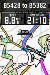
In an earlier post comparing OS Discoverer maps to open source OSM maps, I highlighted a crucial factor which may influence the decision to adopt one or other - the usefulness of various zoom levels, particularly noting the detrimental effect of zooming in too much, beyond a particular point. To show this in greater detail than my previous post, here are some screenshots, taken … [Read more...]
Maps comparison – free OSM and OS Discoverer.

After installing the TalkyToaster OpenStreetmap onto my Garmin Edge 800 (see tutorial here) I think it will come in quite useful after all. I do prefer the look of the classic OS discoverer map when in the middle zoom levels, but I think the OSM map will excel in the fine details of the close up. The screenshots below attempt to show this, with the Velomap thrown in for … [Read more...]
Garmin Edge 800: why you shouldn’t bother with custom OSM maps.
So you're thinking of getting a Garmin Edge 800, probably the best bike computer on the market in 2011/12? There are many different bundles to choose from, and when I was deciding which to go for, I knew I wanted the performance monitoring kit, with the heart rate and cadence sensors. Since I'd read that it was possible to load custom open source maps to the unit anyway, it … [Read more...]